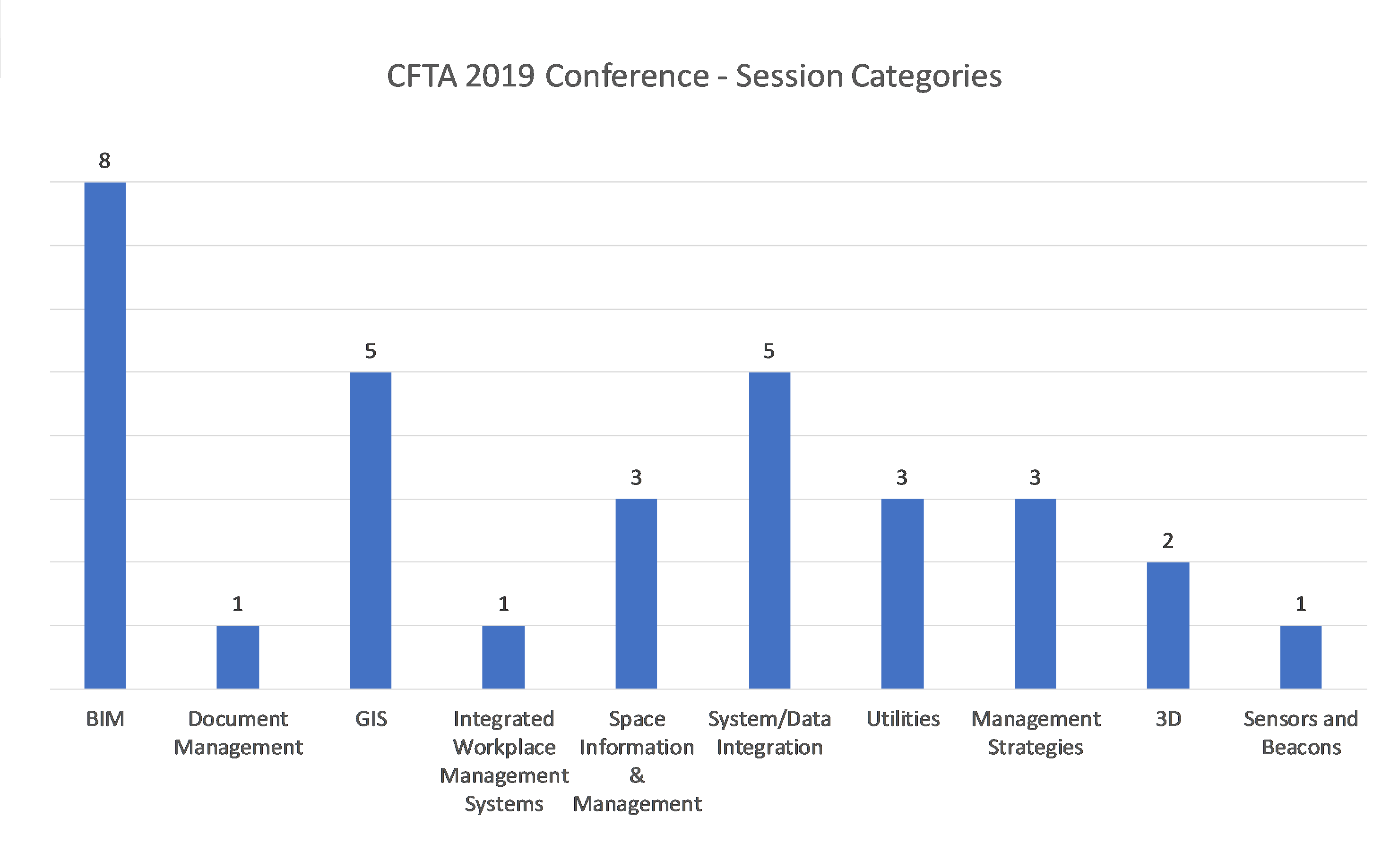
| Session Name |
Session Description |
Organization |
| Toto, I Don't Think We're in 2D Anymore! The U of A's Emerging 3D GIS Framework |
A framework for 3D mapping of the UA campus has been under development in some form for 10+ years. Recently efforts have come together to allow this information to be published in 3D web maps using the Esri Js API 4.1. Work continues on refining the data model, enhancing the data itself, and developing automated publishing workflows. An evolving future roadmap for 3D will be described, including integration with indoor/space data, anticipated use cases, and photorealistic enhancements. |
University of Arizona |
| The University of Tennessee's Road to BIM |
The University of Tennessee Knoxville is in the process of adopting BIM as a tool to improve our project documentation, as-built records, and facility management. We have spent last two year consulting with other Universities that have successfully implemented BIM at their institutions to create our own BIM Implementation Plan. Our vision is to integrate BIM with current GIS practices to create a 3-D representation of campus for better decision making, and understanding of campus needs. |
University of Tennessee |
| Document Management's Role in a Digitally Connected FM Organization |
We will discuss why document management should be a part of your FM organization's overall digital strategy. We will show examples of DM supporting GIS and spatial data revisions, how aligning and leveraging IWMS data within your DM solution can increase the information available through mobile technology. Utilizing DM, in addition to, and strategically with the rest of your digitally connected FM solutions can increase your organizations overall operational efficiencies. |
Michigan State University |
| Mapping the University of Hawaii at Manoa Campus: Year 2 |
The University of Hawaii is currently in its 2nd year as a CFTA member. In that time span, the GIS staff has implemented what they've learned into mapping the UH Manoa campus (UHM). This presentation will share an overview of UHM's GIS efforts: from pre-CFTA days to its current Enterprise GIS setup. We'll also share show how GIS is integrated with our CAD, Revit, AIM (space management), and OnBase (document management) systems and workflows. |
University of Hawaii |
| Facilities GIS at UNT: Curating institutional knowledge, inspiring operations |
Utilizing high-accuracy mapping technology, Facilities GIS collects and curates a wealth of institutional knowledge about campus infrastructure and assets. This rich database supports work in strategic planning, project design, construction as-built mapping, maintenance operations, and community engagement. Learn about the ways we're leveraging traditional field mapping, drone technology, and GIS applications at UNT Facilities to enable location intelligence across the organization. |
University of North Texas |
| Taking Campus Surveying to the Next Dimension |
Messer has begun documenting & mapping campus info & entities by using photogrammetry from drones & more detailed point cloud data from terrestrial scans. Civil site information can be captured quickly & at any time prior to, during, or after a major campus project. In this session we will review 2 projects & how UAV & Laser Scanning was used to document Civil Site information. We will also explore where we are headed with integrating this information with GIS for use by facilities management.
|
Messer Construction
|
| Putting Your Data to Work |
Facility managers seek to equip their teams with smarter tool that will provide actionable insights, drive proactive maintenance, and track the impact of their work for management and resource planning. This presentation provides key lessons learned and examples of value implementing Fault Detection & Diagnostics (FDD) at Western Michigan University (WMU). |
Western Michigan University |
| Housekeeping FTE FM Module Extensions |
FM systems are not geared to calculate FTEs for custodial departments. It's more complicated than FTEs per SF. In 1992 APPA introduced the FTE staffing guidelines but schools are ill equipped to provide supporting data. On 4/4/19 CFTA posted a survey Housekeeping FTE Facility Management Module that measure the need for an FTE calculator on FM system module extensions. The survey and white paper author will present findings and methods used at NCSU to validate staff. |
North Carolina State University |
| It Takes a Village: Total Cost of Ownership |
Implementing a new standard is never easy due to the culture change involved - "That is not the way we have always done it." A new TCO standard looks at all issues involved with the costs of single items, new facilities, existing facilities, and investing using BIM, IWMS, GIS and all the above. The session will discuss the principles presented in Part 1 of the ANSI recognized standard and review implementation objectives coming in Part 2 through case studies. |
University of Texas at Austin |
| Implementing/Using Archibus as Space Management Solution at Stanford University |
As one of the world's leading research universities, Stanford University requires a complex space management solution for its environment; standard implementation procedures and out-of-the-box solutions could not be easily adopted. This presentation will go over key items from implementation through go-live. Topics discussed will include: documenting requirements, vendor review, overview of iSpace (web-based data entry and reporting) and CAD integrations, including graphical reporting tools. |
Stanford University |
| What's Behind Door #3? Interactive Floorplans at the University of Arizona |
The UA has internally developed a GIS-based web application for managing and visualizing space data. This is part of a larger effort to transition from a vendor-solution for Space Management to a full in-house framework. The goals, process, technical framework and results will be highlighted. We will also touch on how a GIS-based approach has allowed building interior information to be re-purposed for other uses such as public wayfinding (e.g. "Finder" app: https://maps.arizona.edu/Finder/) |
University of Arizona |
| Change is good: The Journey of One Facilities Management Department |
UMass Lowell is currently going through many changes in their FM Department. Hiring a Document Manager, the implementation of E-Builder, upgrading their Campus Viewer, as well as implementing new tools for things such as key requests. Concurrently, the FIS Team continues to advance the use of GIS to support data collection and visualization, decision making, and public outreach. Strategies, lessons learned, and how FIS has helped departments along this journey will be discussed. |
UMass Lowell |
| Pepperdine University Consolidates Revit Room & Asset Data to Populate FM & GIS |
This presentation demonstrates Pepperdine University's steps to consolidate & populate Revit room & asset data from a multi-trade, multi-Revit model building project into a single SQL Server database called CodeBook. This open-source SQL server is then used to accurately populate the entire building, room and asset lists and data into PU's CAFM program: WebTMA & GIS program; ESRI GIS. Hand entering COBie and/or Revit asset lists per room for linked Revit project models is no longer required. |
Pepperdine University Malibu |
| Evolution of Field Data Collection Methods at UT |
Evolution of survey methods at UT that take us from tape measures to rovers, total stations, and drones. |
University of Texas at Austin |
| Transform Utilities CAD into GIS |
Details of the approach used by UT Austin to transform our CAD utilities data into GIS. |
University of Texas at Austin |
| Utilizing Advanced 3D Models in Virtual Reality Environments |
Review the latest developments in displaying large scale 3D models in advanced Virtual Reality (VR) environments. VR environments discussed included both holographic and immersed VR platforms. Review a number of technical considerations involved in presenting large scale 3D models in BIM/GIS/Point Cloud formats, and possible ways forward to successful deployments in advanced VR platforms. |
GEOLABS, LLC |
| How to Ensure you are Receiving High Quality BIM Models |
Are you receiving BIM models for your projects? Maybe you have a set of published BIM requirements detailing what you want from those models. But, do you have a Quality Assurance (QA) program in place? This session will explore the tools and processes you need to have to ensure you are receiving quality BIM models. We will discuss: Revit templates and libraries, configuration files for classifications and COBie deliverables, and standardizing your BIM 360 sites. |
CADD Microsystems, Inc. |
| BIM for Owners: Setting the Standards to Ensure the Outcome |
We will start with a discussion on various Owner BIM Guidelines and do a compare/contrast walk through. Using a choose-your-own adventure style template, we will then outline a low cost Owner's BIM Standard Draft together focusing on those BIM uses which have been adopted by AEC professionals as their standard level of care. We will conclude with a discussion of the project specific circumstances or risks that would warrant a more robust level of BIM use. |
Modulus Consulting |
| BIM & CAD to FIM: A new model of Hybrid |
Campus planning involves sorting thru CAD & BIM deliverables in overwhelming fashion. BIM may be the future but what about today's needs? How do you separate but still share between the two worlds of CAD and BIM? In this session, start to develop a game plan for a hybrid environment of CAD with an eye toward BIM with current and future deliverables. Learn about a phased implementation plan to transition from CAD to BIM and avoid common pitfalls, one building at a time. |
CADD Microsystems |
| "LOD What?: Realistic BIM Expectations from your A/E/C Partners" |
This presentation will demystify the term "LOD" - aka Level of Development - as it relates to BIM content creation and what Owners should be able to ask for from their Design & Construction industry partners.There is no such thing as an "LOD xxx" model - so let's unpack:-correct definitions for LOD-how it can help you as an Owner-why it matters-what to ask for, and how to ask for it-what can you expect at the end of the day with the model content you want to receive |
McCarthy Building Companies |
| Digital Twin of Campus via integration of BIM with GIS, IoT, FM |
The technological advances of the recent years include not only software upgrades and cheaper/better sensors but also a wider adoption of open industry standards. The presentation will review how open BIM (COBie, IFC), GIS standards (CityGML, IndoorGML), IoT/BAS protocols (OPC, BACnet), and point clouds (e57) can be used together to create a virtual copy of your campus, or how it is often called now: "Digital Twin". |
EcoDomus, Inc. |
| Utilizing Microsoft HoloLens to Verify As-Built Models for an FM-Capable BIM |
An FM-capable BIM must contain fully connected building systems with model geometry at the required level of development (LOD) and level of accuracy (LOA) to insure the model is consistent with existing field conditions and to enable facility managers to understand, analyze and make well-informed operating decisions. The HoloLens provides AR capabilities to augment graphical information and enable users to review systems, and compare BIM elements to corresponding real world components. |
Virtual Facilities Consulting |
| Transitioning your campus assets to GIS |
More and more campuses are seeing the benefit to having their assets managed in GIS. This presentation will discuss the process for bringing your assets from hard copy maps, field sketches, and CAD drawings into an Enterprise GIS. Information provided will discuss how to design your database, the workflow to import all your data, and how to manage it going forward in GIS. |
Langan |
| Leveraging GIS to Organize Your Campus Facilities Information |
Facilities information is produced by many different groups across campus. They each have their own business cycles, source systems, and formats. Luckily, we can use location to organize this information and make it available in combination with other data securely in the context of business-focused apps. The open and interoperable nature of GIS makes it an ideal systems integration platform. Learn best practices from practitioners with many years of experience. |
PenBay Solutions |
| Your Campus Guide to Sensors and Beacons |
The future of campus facilities is technologically enabled, with greater automation through smart devices like sensors and beacons. Imagine a campus where you know which meeting rooms are utilized to avoid overlap, how many people are in the room and its campus location campus. If light bulbs need to be replaced or a PowerPoint fails' notifications can be sent to facilities managers. From simple conveniences to core insights, learn how sensors and beacons can maximize campus oversight. |
SpaceIQ |
| Increasing Productivity Through Asset Information Collection |
When budgets are tight, organizations looking to increase facilities management productivity don't have the option to hire more staff. By building a database of reliable space and asset data, your team can waste less time searching for information and spend more time in the field completing tasks. This presentation will outline value that accurate space and asset data brings to organizations, how to collect this information, and how this information increases productivity and reduces costs. |
AkitaBox |
| Government Agency Integrates VR, EAM, & GIS for Improved Facility Operations |
We helped a government agency develop an integrated facility asset management solution for optimizing operations for one of the largest buildings in US. Immersive 360 camera used to scan 100,000 sf of mechanical space to generate seamless indoor "virtual reality" (VR) visualization of spaces. Spaces are post-processed to add image-based asset tags and capture view point location data. These data are integrated with EAM & GIS. Value recognized for facility O&M, project management, and training. |
Patrick Engineering |
| Scope and Scale: Condition Assessment Innovation and Justifiable Capital Plans |
How can an organization make conditions assessments more accurate, determine scope and budget of plans and projects? How can it balance transparency and efficiency, while setting priorities and showing traceability to deficiencies? Learn how a school district overhauled its conditions assessments, project management, and capital planning, leading to justifiable plans and funded improvements. We'll show you how every educational institution can benefit from their lessons learned. |
Intellis |
| The challenges of capturing fiber networks |
Fiber networks are a complex challenge to capture and manage, in part because there are multiple levels of relationships - Duct backs containing cables and cables containing strands. Further, connections can be spliced along the way, cables may go through vaults without breaking and there may also be devices like multiplexors. Understanding the fiber asset data and representing them in GIS structures is a challenge that this presentation will address. |
Open Spatial |
| Venue Management via and Indoor Mapping Data Format - BIM/CAD/GIS |
A Venue Mgmt Platform provides users the ability to convert their existing floor plan data from CAD files, BIM Models, & Geospatial DB files into Apple Maps certified Indoor Mapping Data Format. Features included in CAD, BIM & GDB file types are converted through a customized workbench & stored within the platform to help facilitate relationships between an org. in any industry. We created a single source of truth that apps can leverage to provide opex savings, data analysis & visualization.
|
Arora Engineers, Inc |
|
Campus Planning: Why a digital utility atlas is the key to knowledge succession
|
Schools have succession plans for the important aspects of their institutions — endowments, faculty, curriculum, leadership. What many schools don’t have is a succession plan for the most visible, tangible part of their institution: the campus itself. As paper records are forgotten under piles of other information, and sources of institutional knowledge retire, that history is in danger of being lost. A digital utility atlas is vital to protecting and planning the school’s future. |
DGT Associates |